

Thank you for your interest!
I’m Derek Galon, offering Drone Mapping in Dominica & the Caribbean
I offer a wide variety of photo, video and filming services in Dominica and Eastern Caribbean. I am also an experienced drone pilot, combining top quality imaging with safe flying.
Drone mapping – an innovative technique designed to improve and speed-up surveying and map production work is only as good as images taken by your drone pilot/photographer. As it is a photography-based technique, I can offer you advantage of better work.
Ready products include ortho-mosaic photo-based (2D) maps (orthophotography) that are incredibly precise, with GPS location data (Geo-TIFF), special elevation maps that give you overview and details of terrain and building elevation, and 3-D models to look at your location from around and understand its topography better. You can print it, export it to Google Earth for precise set in GPS environment, or open using one of many OBJ viewers, or import into AutoCAD.
Excellent quality drone mapping in Dominica at local prices.
My work is scallable – from relatively simple ortho-mosaic mapping with GPS positioning accurate up to 1/2 meter (any point on map shows GPS coordinates) and maps accurate up to 1/2 centimeter, to even more precise mapping using ground GPS stations for up to an inch precise positioning.
Maps and models can cover smallish locations like a single building construction, or a small lot for surveying – and also several acres big stretches of land for commercial projects, mapping of existing structures for map making, detailed engineering safety inspections, crop evaluation/ inspection, disaster and rescue, construction site progress, and so on.
While superior in quality to satellite or helicopter imaging, it is also significantly cheaper. Drone mapping can also save lots of time for jobs that would otherwise be conducted on foot or driving around.
Have a look at video on right side (not mine) explaining basic advantages of drone mapping.
Short video explaining what drone mapping is, and its benefits. While it does not show it all, it gives basic understanding of this great new technology. (Found on Youtube and shared)

ABOVE: Photo of computer screen with 3-D model open. Note blue measurement line on left of the building. It gives you not only distance from spot to spot, but also GPS info, elevation difference and more. You can calculate distances, volumes, heights, and more. Turning the model at different angles helps understanding the location. Click to enlarge.

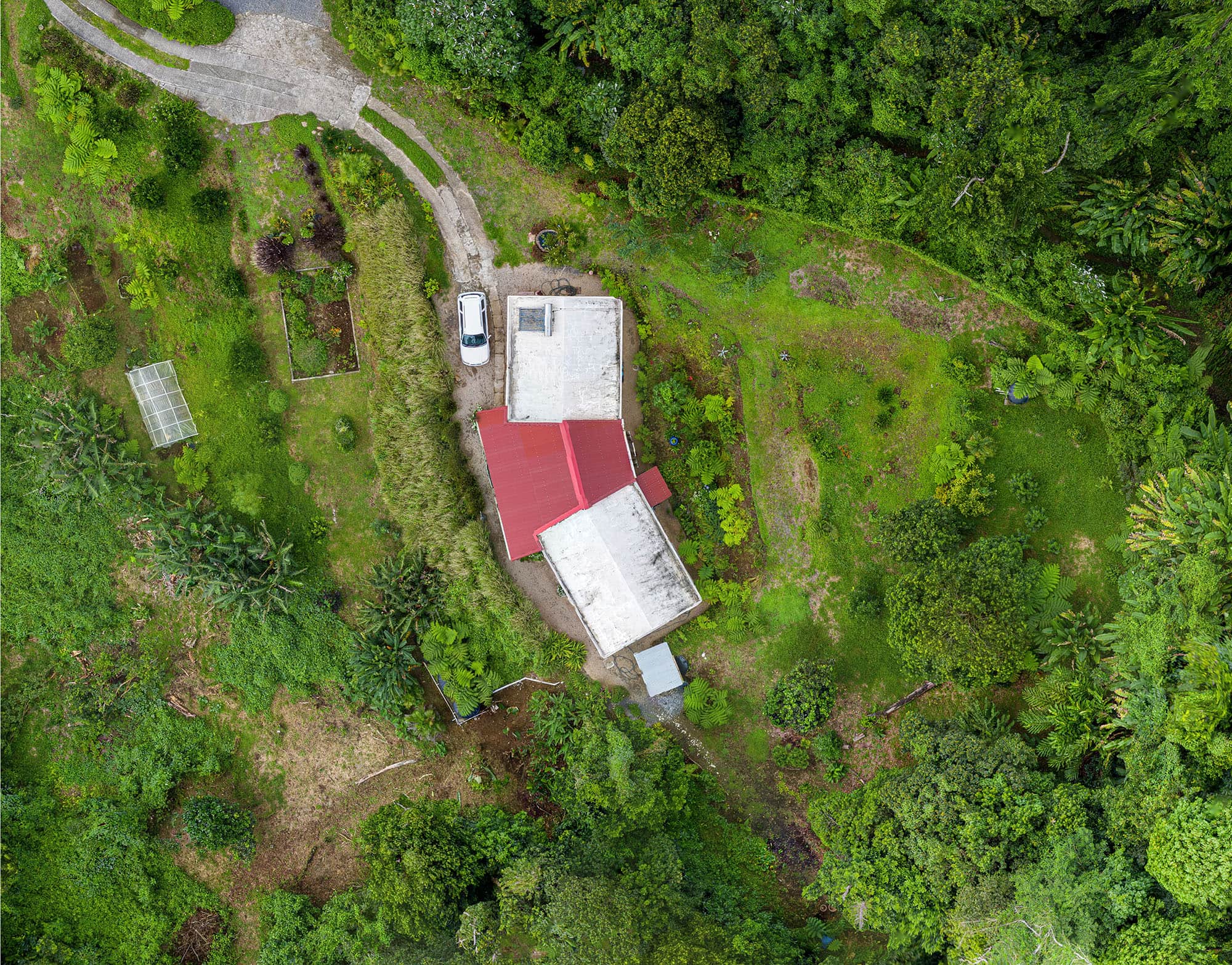
ABOVE: See the difference of my quality.
Photo A – typical drone mapping quality done with auto settings forced by most of mapping drone apps. Note lack of contrast, soft details, sometimes completely lost on white surfaces.
Photo B – same spot captured with my own “go around” these usual forced auto settings. It takes more time and skills, but notice ALL detail on white roof, visible dirt on tubes of roof solar heater, increased sharpness and colour, and so on. Drone map or 3D model is made of hundreds (sometimes thousands) of single images. I edit them all, making sure quality and details are as good as possible. These details may be VITAL for quality of safety inspections, and other such tasks.
Flying a drone is not everything in Drone Mapping. It is just a beginning. Knowledge of photography is vital. It is a combination of science and art. Let my 40+ years of experience make the difference for you. Click to see enlargement.
Simple preview of a 3-D model to give you a glimpse at possibilities. Move mouse over.
ABOVE: Ortho-mosaic 2-D map. It looks like a photo from above, but it is much more than that. It is done often from hundreds of photographs (can be a huge image), optimized, corrected for angle, levels, brightness, and stitched. It creates a super-precise professional map with every spot having detailed GPS coordinates, height and topography details, and more.
It can be used to measure precise distances, to evaluate details for inspections, create commercial maps, calculate volumes and heights, and more. Available in Geo-TIFF format, it can also be uploaded to Google Earth and other applications for a more advanced use.
I look forward to use my professional experience and state of the art drone gear to assist you. I can travel to your location. Contact me for details. Thank you!
Client's Comment:
I overlaid the original topographic map the architect originally did for the site with your drone survey and it was so bad I wouldn’t use it as toilet paper. So glad we got you on board.